INTERNATIONAL COOPERATION RESEARCHES
Remote Sensing plays a significant role in acquiring useful information for conservation of natural resources and sustainable development. LTDA provides technical assistance, consultancy and researches applications in the field of remote Sensing for natural resource evaluation.
Topics of interest include:
- Land Unit approaches, combining field data and satellite images
- Maps of environmental changes, land cover classification, definition of hydrological-related parameters.
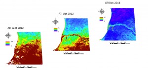
- Remote sensing for costal mapping (COAST)
- Satellite remote sensing for the identification of suitable manual drilling areas (UPGRO)
- LTDA also offers training. Currently is involved in the Master Gestione delle Risorse Idriche nella Cooperazione internazionale, University of Milano Bicocca, as well as it has been involved in a training course at the Universidad del Azuay , Cuenca-Ecuador
- Former collaborations have taken place with the Istituto Agronomico per L’Oltremare (IAO) in Tunisia, Eritrea, Bolivia. Soil erosion in Eritrea (FAO report, 1994)
7,015 total views, 4 views today