
LAND SURFACE PARAMETERS
The coupling between atmosphere and biosphere is of particular importance over land surfaces from both the atmospheric and hydrological point of view. Optical remote sensing is a powerful tool for deriving information of land surface parameters at varying spatial and temporal scales. Emphasis is placed on the use of radiative transfer modelling of the atmosphere, canopy, soil, and snow, as well as on algorithms for the semiempirical estimation of biophysical and geophysical variables.
LTDA collects spectral measurements and vegetation biophysical parameters at ground level and it makes use of multispectral and hyperspectral images to generate maps of parameters and processes such as surface albedo and temperature, LAI, Cab, Cw and sun-induced fluorescence. These studies help for precision farming applications, species recognition and in general to parameterise ecological/hydrological models at different spatial and temporal scales.
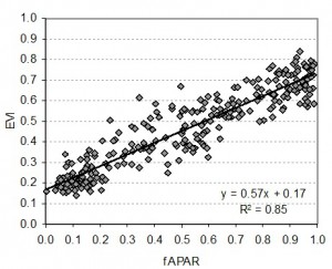
Retrieval of vegetation biopysical and biochemical parameters from empirical models and physically based models (Colombo et al., 2003; Meroni et al., 2004, Colombo et al., 2008; Panigada et al., 2010)
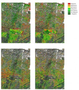
Chlorophyll concentration maps on hornbeam and oak at harth forest from Hyplant sensor
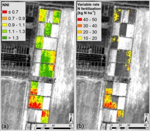
Current studies deal with the use of fluorescence, PRI and canopy temperature for water stress detection and nitrogen status assessment of cereal crops through hyperspectral imageries (Rossini et al., 2013; Cilia et al., 2014; Panigada et al., 2014; Rossini et al., 2015)
New! Discriminating irrigated and rainfed maize with diurnal fluorescence and canopy temperature airborne maps (Rossini et al., 2015)
8,038 total views, 1 views today