
URBAN REMOTE SENSING
Urban Remote Sensing is a powerful technique for understanding urban quality traits, as Improving and conserving open space has been proven to deliver economic, environmental and social benefits.
Main activities are in the context of:
•Land consumption evaluations
•Classification of surface urban categories
•Asbestos detection from airborne/UAV hyperspectral sensors
•Vegetation and habitat quality
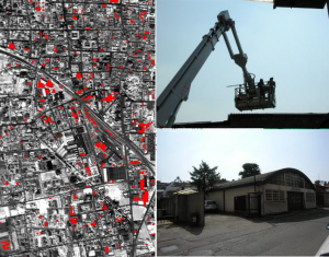
Mapping vegetation cover types and asbestos from MIVIS data
New! Asbestos Cement Roof Mapping and Deterioration Assessment from Hyperspectral Aerial Images. Cilia et al., (2015)
7,118 total views, 4 views today